Introducing The Image Resector: A Geolocation Project
Are you interested in pinpointing the location of an image on a world map? Look no further than Image Resector, a groundbreaking project that utilizes surveying techniques to determine the geographical position of an image using known reference points.
Geolocate Images with Precision
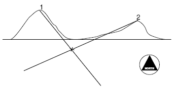
The Image Resector project employs the surveying method known as resection to accurately identify the location corresponding to an image based on known coordinates of reference points within the picture.
How It Works
Using Image Resector is straightforward:
- Select Your Image: Enter the image you want to geolocate.
- Select Reference Points: Identify at least two distinct points within the image whose real-world geographical coordinates are known.
- Input Coordinates: Input the coordinates (latitude and longitude) of these reference points.
Leveraging Resection Technique
Resection, a fundamental technique in surveying, is employed to calculate the position of the camera (or observer) when the image was captured, based on the known coordinates of the reference points within the image.
Key Features
- Image Geolocation: Determine the approximate location where the image was taken on a map.
- Surveying Accuracy: Benefit from the precision of resection techniques used in professional surveying.
- Easy to Use: User-friendly interface for inputting reference points and uploading images.
Get Started Today!
Discover the power of geolocating images with Image Resector. Whether you’re exploring landscapes, analyzing historical photos, or investigating remote locations, this project offers a unique way to connect visual data with geographic coordinates.
>> Home